
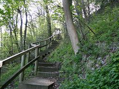
Benthall Edge Wood
Benthall Edge Wood forms a spectacular backdrop to the Iron Bridge. It runs along the southern slopes of the Gorge and rises 100 metres to a plateau above the River Severn.
More information (map and video)
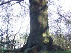
Benthall Edge Wood is now a Site of Special Scientific Interest (SSSI), an area of national conservation importance. One of the critical reasons for its special nature is that the woodland marks a clear transition between lowland and upland types. Oak, birch, rowan and holly dominate the upper slopes, while ash and wych elm are characteristic of the lower slopes. The wood is also home to one of Britain’s rarest trees, the large-leaved lime.
Benthall Edge Wood can be explored in some detail in the Trust’s publications Benthall Edge: Five Historic Guided Walks and The Lime Trail of Benthall Edge

Bower Yard Limekiln
Visible from the Severn Valley Way, this bank of limekilns is one of the best preserved monuments of an industry which was once of great importance in the Gorge. A steep inclined plane linked the kilns with the quarries on Benthall Edge.
More information (map and video)
It is known that the kilns closed sometime in the mid-19C and then enjoyed a brief commercial revival in the 1920s and 1930s when perhaps the economics of extraction became favourable again.
In 2010 the trust rasied £70,000 to repair the lime likns. Sections of the top and corner where rebuilt as was the buttress. the remaining parts where repionted and a new saftey fence was erected.
To find out more, follow the link to Benthall Edge: Five Historic Guided Walks or take a look at the leaflet The Lime Trail of Benthall Edge

Captains Coppice
Captains Coppice is a 4.5 hectare (11 acre) area of woodland on the western valley slopes of Coalbrookdale. It contains maturing beech and sycamore, with some ash and oak, and has been managed as plantation woodland since the 19C.
More information (and map)
Volunteers monitoring the woodland condition in Captains CoppiceIn spring and early summer, the woodland floor is carpeted with the bright green foliage of wild garlic, a carpet which later turns white as the plant pushes up its many spiked flowers. The air is often heady with the plant’s distinctive smell.
Today the lower area of the wood is leased to the Green Wood Centre, and is being coppiced once again to provide small-diameter material for a variety of traditional crafts and courses run by the Centre, such as hedgelaying and hurdle-making. A new path has been created through the lower wood running parallel with Station Road making the route more accessible and safer to walk along.
Captains Coppice can be accessed along a public right of way through the wood. The path climbs steeply up from the road via a flight of steps.

Dale Coppice
Dale Coppice cloaks the eastern valley slopes above Coalbrookdale and adjoins the open space of Rough Park in Madeley.
More information (map and video)
In 2011, three interpretation panels were placed where Richard Reynolds built a cottage and established a garden for his daughter Hannah, and a temple as a shelter for walkers of the time.
Dale Coppice is ancient semi-natural woodland, where today oak and beech dominate. The wood is also home to many different species of bird and mammal, including sparrowhawks, woodpeckers, tawny owl and the noctule bat, one of the UK’s largest bats.
Dale Coppice can be explored along a network of paths, many of them corresponding to Reynolds’ Sabbath Walks, which are described in detail in the Trust’s publication: Coalbrookdale: Three Historic Woodland Walks . Also have a look at the new Sabbath Walk Trail Leaflet.
For more information you can view the management plan.

Haywood
Haywood is a complex of woodland and grassland above Coalport. The area has a south-facing aspect, and walks across the open grassland can be glorious in the sunshine.
More information (map and video)
Historically, the area played an important role supporting local industry. In the 18th and 19th Centuries it formed part of the Hay Farm (much of which today is a golf course) owned by the industrialist Darby family, where hundreds of horses were reared for use in industrial enterprises in the Gorge at the time.
Haywood can be explored along a network of footpaths, some of which are described in detail in the publication: Jackfield & Coalport: Five Historic Guided Walks.
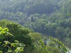
Lincoln Hill
Lincoln Hill offers one of the finest views of the Iron Bridge from a point known as the Rotunda. The edifice built there in the early 1790s had cast iron pillars and a domed roof. It also had a revolving seat with panoramic views of the surrounding countryside.
More information (and map)
Lincoln Hill is today a Site of Special Scientific Interest (SSSI), an area of national importance for its geology. It is composed of limestone, an uplifted sea-bed formed 420 million years ago when Britain lay south of the Equator. The process of forming coral reefs would have been very much like that underway in the shallow seas of the Caribbean today.
The woodland of Lincoln Hill can be explored by a number of historic footpaths. These are described in detail in the Trusts publication: Coalbrookdale: Three Historic Woodland Walks and the new walking leaflet The Sabbath Walks Trail
For more information you can also view the management plan.

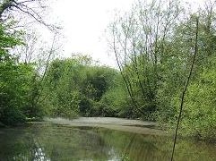
Lydebrook and Loamhole Dingle
Loamhole and Lydebrook Dingle are two narrow connected valleys which sit within a very rich and varied landscape at upper Coalbrookdale. Much of the woodland associated with Lydebrook has been undisturbed for a long time, and has the feel of the original wildwood about it.
More information (and map)
Lydebrook Dingle and is a Site of Special Scieintific Intrest (SSSI) and is of national conservation importance, of particular importance is the rare cranefly Lipsothrix nigristigma, found in only a handful of sites in the UK (and nowhere else in the world). Its larvae feed on wet, rotten wood lying in fast-flowing streams.
For more you can view the management plan.

Madeley Wood Hall
At the eastern end of Lloyds Coppice is the site of Madeley Wood Hall, a late 19C manor house belonging to the Anstice family, local industrialists who operated the Madeley Wood Company.
More information (map and video)
Although the Hall was demolished in the 1920s, there are surviving remains of the former stores. These were built into the hillside, this may have given insulation from the ground above to maintain an even temperature for storing food
If you have any additional information, reminiscences or pictures that would increase the Trust’s knowledge of local history, please let us know at staff@severngorge.org.uk

Oilhouse Coppice
Oilhouse Coppice and pastures is an area of land on the gentle southern slopes above Lightmoor Stream. It encompasses woodland and flower-rich pasture, altogether extending to 8.5 hectares (21 acres).
More information (and map)
The grassland of Oilhouse pastures is particularly important in supporting a wide variety of flora, typical of old hay meadows. Sweet-vernal grass, cowslips and yellow rattle all thrive here. This last species reputedly derives its name from the rattle of the seed in its pod, at which point folk-lore indicated it was time to mow the hay.
Oilhouse Coppice itself is ancient woodland but clearly from its name served other industrial uses, probably during the 18C and 19C. From spring onwards, the woodland floor is carpeted in ramsons, giving off its pungent garlic aroma. The plant dominates large areas, but elsewhere there are many other species, such as bluebell, wood anemones, and wood sorrel.
For more information you canview the management plan

Ropewalk
The Ropewalk Meadow is a small but wonderful example of a traditional hay meadow an area that has possibly never seen artificial seeding or fertilisers. The soil’s low fertility actually ensures a wide biodiversity; well over a hundred different plant species regularly being recorded.
More information (map and video)
Nearby is Sunniside Deer Park, a small, enclosed area of formal park laid out by the Darby family in the late 1700s. Much of the evidence of the park has now gone (including the deer), although a few veteran Beech and Limes survive, as does a boundary brick wall to the west of the Ropewalk Meadow. The Trust’s office is now based here.
For more information you can view the management plan
Sutton Wood
Sutton Wood is the Trust’s most easterly parcel of land, covering the northern slopes of the Severn valley as the river flows out of the Gorge. It is a large wood, covering 28.5 hectares (70 acres), and contains larch as well as a variety of broadleaves.
More information (map and video)
Sutton Wood is a Wildlife Site, and one of the richest sites in the Gorge for birds such as siskin, redpoll, whitethroat, and garden warbler. It is also home to the scarce white-letter hairstreak butterfly. This species feeds on elm, and although many of these had to be felled during the major outbreak of Dutch elm disease in the 1970s, enough specimens survive in the understorey for the butterfly to do well.
The wood is traversed by a number of paths, some of which are explored in detail in the Trusts publication: Jackfield & Coalport: Five Historic Guided Walks.
Workhouse Coppice
Workhouse Coppice is a 5.42ha (13.39 acres) woodland on the northern edge of Broseley and adjoins Benthall Edge Wood. It is an ancient semi-natural woodland dominated by even-aged oak, with a dense shrub layer of holly.
More information (map and video)
A public footpath bisects the wood, with a number of subsiduary footpaths leading off this; one of which links to the footpath network through Benthall Edge Wood.
The Severn Gorge Countryside Trust manages Workhouse Coppice on behalf of the Woodland Trust.